.jpg)
The Nav3D simulation software for satellite occlusion and multipath effects in complex environments is based on real-world modeling and simulation scenarios, simulating the propagation effects of GNSS signals in specific environments. We have independently developed a complex geometric and physical editor that uses the creation of 3D synthetic environments or real 3D maps, combined with ray tracing technology, to calculate and analyze the propagation path of GNSS signals in complex environments, which is the first in China.
The Nav3D simulation software for satellite occlusion and multipath effects in complex environments is based on real-world modeling and simulation scenarios, simulating the propagation effects of GNSS signals in specific environments. We have independently developed a complex geometric and physical editor that uses the creation of 3D synthetic environments or real 3D maps, combined with ray tracing technology, to calculate and analyze the propagation path of GNSS signals in complex environments. It is the first in China, Benchmark similar Sim3D simulation software products from abroad.
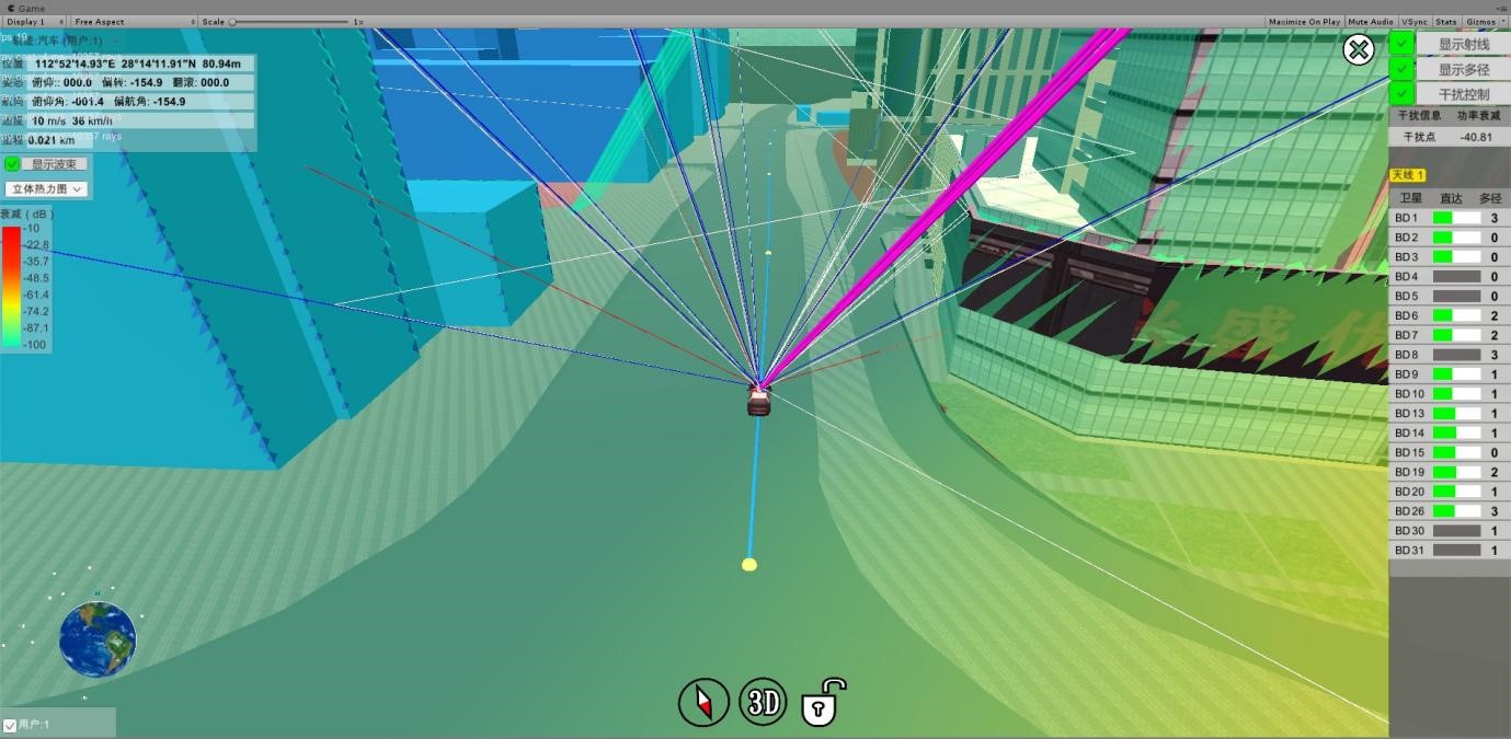
During Nav3D simulation, satellite navigation signals will interact with the real 3D environment, simulating the real signal path, and controlling the simulator to output realistic RF signals. The actual output signal includes the shielding of the street, Viaduct, canyon and other surrounding environments from the satellite direct signal; One or multiple reflections from the ground, trees, buildings, mountains, canyons, and other factors on the satellite, including reflection angle, area, and reflection coefficient, are simulated to simulate the power attenuation and delay of possible multipath signals. The relevant signals can better meet the requirements for signal occlusion and multipath effects in high-precision and anti-interference testing.
Nav3D仿真模拟时,卫星导航信号会与真实的3D环境交互,模拟出真实的信号路径,并控制模拟器输出逼真的射频信号。
 The scripted editing ability of the testing plan planning function and testing process allows users to plan and design the testing plan according to the testing requirements before the experiment, and edit the testing process. Users can manage and configure the testing scenarios and processes according to the testing needs of different receivers and different testing tasks and objectives, and use them as different testing templates.
 Perform manual or batch Test automation based on test scenarios and test processes, and have one click Test automation function for user terminal technical indicators.
 After each test project is completed, it can automatically analyze and evaluate the test data and generate test reports, with the function of automatic analysis and evaluation of user terminal technical indicators.
 Multiple testing and evaluation modes are available, including automatic, manual, and single mode.
 Real time analysis and evaluation of test data, capable of analyzing and comparing test data in real time, completing functional and performance indicators such as pseudo range measurement accuracy, positioning accuracy, channel consistency, bit error rate, etc., and automatically generating data processing reports.
 The real-time analysis and evaluation function of test data allows for knowing the statistical results of indicators without waiting until the end of the test, facilitating the timely termination of problematic receiver tests and saving testing time.
 Comprehensive display function: It can comprehensively display various information such as work status, simulation scenarios, positioning results, data processing reports, etc. in various forms such as data, tables, graphics, etc.
 Database management function, which can automatically classify, store, query, and count simulation and test data, and has automatic data storage and retrieval functions.
 Equipped with automatic evaluation of test results and automatic generation, printing, and export of test reports.
采用GPU并行加速遍历光束树,算法效率提高14倍。
|
采用GPU并行加速遍历光束树,算法效率提高14倍。 |
|
|
能以100Hz的频度实时仿真四大导航系统、32路多径信号。 |
|
|
支持高达100万三角形的3D场景建模。 |
|
|
支持环境模型的参数自定义,可对3D模型的表面材料,电磁波反射系数,多径信号伪距变化速率等参数进行精准设置。 |
|
|
支持多径数量: |
0~32路可自定义。 |
|
多径反射次数: |
1~6次可自定义。 |
|
环境模型:简单3D模型、近似3D模型、真实3D模型。 |
|
|
简单3D模型: |
使用Nav3D内置地形和建筑物模型,手动编辑,自动生成3D环境模型。 |
|
近似3D模型 |
使用地图公司提供的建筑物和地形模型数据,在线实时生成3D环境模型。 |
|
真实3D模型: |
使用无人机倾斜摄影,经后期建模、校正和表面精细化处理等操作,生成3D环境模型。 |
|
载体模型:内置模型、载入模型。 |
|
|
内置模型: |
内置多种载体模型,如行人、汽车、直升飞机、卫星等载体,可快速实现GNSS信号受载体自身遮挡效应的模拟。 |
|
载入模型: |
内置载体无法满足需求时,通过因特网或其他方式获取的载体模型可导入Nav3D使用,支持的模型格式有3DS、SKP、OBJ、FBX。 |
|
支持多载体同时模拟,同时模拟的载体种类无限制,可选载体库中的任意载体。 |
|
|
最多可支持4载体的单天线模拟,载体间以固定位置或变化位置保持同步,可实现多载体的同步编队模拟。 |
|
|
载体天线:支持单载体多天线设置,单个载体最多可挂载3个接收天线,各天线的位置可自由配置,接收天线的衰减模型可自由配合或外部导入。 |
|
|
载体轨迹:支持3D可视化编辑和在线地图编辑等多种方式。 |
|
|
预留天气数据导入接口,支持外部天气模型数据的导入。 |
|
| 仿真信号规模 | |
| 卫星通道数量 | |
| 多径信号数量 | |
| 信号精度 | |
| 伪距精度 | |
| 伪距变化率精度 | |
| 通道一致性 | |
| 信号动态 | |
| 仿真高程 | |
| 相对速度 | |
| 相对加速度 | |
| 相对加加速度 | |
| 外部轨迹实时性 | |
| 信号延迟 | |
| 数据更新率 | |
| 信号质量 | |
| 杂波抑制 | |
| 谐波抑制 | |
| 信号电平 | |
| 电平调节范围 | |
| 电平调节步进 | |
| 物理和电气性能 | |
| 整机尺寸 | |
| 整机重量 | |
| 电源、功耗 | |
PNT测试领域的最佳选择,全套实景建模与复杂环境模拟能力,半实物仿真实时性高达1ms。
Need help or have a problem?
Contact Us